Severe Weather: Southwestern Monsoon
By Michael FaginWeather ConditionsWith 0 commentsSevere Weather. The southwestern monsoon, generating severe weather on the West Coast, has been the root of many deaths and hundreds of millions in damages, particularly from flash flooding and lightning. Those figures manifest before any subsidiary threats that may be caused by the storms, such as wildfires.
The North American monsoon – a.k.a the Mexican/New Mexican/Arizonan monsoon – vs. several others such as Asian and South American monsoons, has its own unique characteristics. Of the potential severe storms on the West Coast, those from the southwestern monsoon comprise local precipitation maximas rivaled only by abundant late spring moisture.
When moist air gets introduced to the hot, dry air of the American southwest, it explodes into spotty rain that’s often heavy, along with all the threats that stem from intense thunderstorms, perhaps even microbursts. The monsoon is largely guided by the local topography, which doesn’t respond well to rain and predictably leads to flash flooding. Characteristic afternoon arrivals are due to the delay caused by the sun’s energies bombarding the surface, especially near the daily solar apex (probably not exactly but close to noon), then the time it takes to convect into the inches of air next to the ground, slowly fly up and finally find their way to the convective condensation level – where it’s cool enough for clouds to start forming.
For the most part, the regional moisture deficit requires getting fed by surrounding atmospheric disturbances in order to generate rainfall. Terrestrial heating opens the door wide for that by lowering the atmospheric pressure above the surface. It leads to a region of high pressure far above the surface, which works to cap the upward transfer of heat, preventing it from rising higher in the sky, concomitantly raising the surface temperature. Lower pressure means surrounding higher pressures from all cardinal directions will move toward it. In the instance of the American southwestern monsoon, moist winds from the southwest and sometimes the southeast do the feeding.
The phenomenon starts in May but doesn’t simply stay put over the south. Its origin is geographically centered over Mexico’s Sierra Madre Occidental mountains and the Mogollon Rim. The regional subtropical ridge moves northward in the summer and, with it, Lows that may form there. On the US side, the monsoon is most pronounced in southeastern Arizona and adjacent land in New Mexico. Arizona receives half its rainfall from it and has the longest monsoon season in the US: Jun. 15 – Sep. 30. Areas northward see progressively smaller seasons. When it does head that way, it can encounter as far west as California and as far east as Colorado. If the forces pushing it northward are strong enough, the weather may be able to reach the Pacific Northwest
Severe Weather Southwest Monsoon
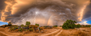
The Strength of the Southwestern Monsoon, Generating Severe Weather on the West Coast
Before radar and satellite data, the isolated nature of the typical storms of the southwestern monsoon over predominately extremely rural areas made understanding variations in the local weather impractical. Just years ago home to over 10 million, now over 12 million, the area’s population is booming. As the area grows, so will interest in its weather and the data required to expand our knowledge about it.
There is no direct evidence, at best weak, indirect (proxy) evidence, of the long-term historical strength of the southwestern monsoon. It, however, is known that its influence has grown stronger over the past couple decades or so. The cause has been moisture from around the Gulf of California, which is the monsoon’s typical primary feed. It can get fed very quickly into the wind pattern, which can easily betray long-to-medium term forecast models.
Predicting the intensity of the strength of the southwestern monsoon, generating severe weather on the West Coast, is perhaps more difficult than any American storm systems because it is the least understood. The ranges between activity, inactivity, dryness and moistness are extremely variable, too much to presently accurately forecast long-term. Certain atmospheric patterns, such as El Niño and the Madden Julian Oscillation, can intensify convection. Those functions overlay the patterns of the Atlantic and Pacific Oceans and also from orographic influences to enhance the storm-brewing potential of the southwestern monsoon
The best approach for meteorologists monitoring it is to keep a watchful eye peeled. Diligence from publicly available weather data and forecasts is much more practical and convenient than from years past but still can’t stack up to hiring a seasoned meteorologist. Insurance damage? Forensic Meteorologist at West Coast Weather can review historic data to determine wind speed, rainfall totals, and hail.
This article was written by Meteorologist Geoff Linsley