Cyclones-Typhoons-Tornadoes-Fujiwhara Effect
By Michael FaginHurricane, Weather ConditionsWith 0 commentsCyclones-Typhoons-Tornadoes-Fujiwhara Effect. The Fujiwhara effect became of a subject of meteorology in 1921, when Japanese Meteorologist Sakuhei Fujiwhara focused on the movements of whirlpools and other vortices and then researched the physics present when they approach each other. A similar phenomenon is possible when atmospheric vortices merge. Many weather features, including generic Lows and winter weather systems, can participate in a Fujiwhara effect interaction but it’s most obvious in satellite perspectives of typhoons.
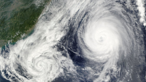
The Fujiwhara effect
The details of Fujiwhara effect interactions depend on cyclones’ sizes, distance apart and prevailing atmospheric conditions. Tropical cyclones need to be within 1,400 km (870 mi) of each other to merge their atmospheric systems. Planetary rotation makes the Coriolis force play a stronger role over extratropical waters, extending the possible reach of extratropical cyclones an extra 600 km (totaling 1,200 mi.) Significant acceleration occurs at about half those distances.
The dynamics behind the occurrence and sustainability of the Fujiwhara effect are still only partially understood. It is debated whether it’s wind divergence or vorticity advection that causes systems to merge. Several atmospheric forces are involved and normally work to inhibit the structuration of the phenomenon. Good examples of it historically emerge just once every few years. There has thus been limited ability to study it. Nevertheless, meteorologists have tactics for forecasting its effects. For instance, surface winds are subject to more variability than higher in the sky, so meteorologists look up to roughly 18,000’ (500 mb) to better predict if the Fujiwhara effect may come into play and linger.
Satellite Tornadoes
Satellite tornadoes are a distinct weather phenomenon often confused with but at least reminiscent of the Fujiwhara effect. Multiple tornadoes called subvortices are often spindly in relation to their associated parent tornadic structures. Less often, they are completely separate tornadoes within the same storm, called satellite tornadoes. Two or more can influence each other and share wind trajectories while remaining independent. One is often anticyclonic but all can be cyclonic. Usually they’re associated with very large and intense tornadoes, wherein the atmospheric supplies exist for several to spawn
The Fujiwhara Effect in 2017
The Fujiwhara effect made headlines this July when Hurricane Irwin interacted with Hurricane Hilary south of Mexico, wherein the trajectories of both began to accommodate each other. Many said it was an historically unprecedented second instance of the Fujiwhara effect in one year.
Earlier in the month, Pacific Tropical Storms Noru and Kulap almost demonstrated the Fujiwhara effect but Kulap collapsed into Noru and never altered Noru’s path. Noru then became the season’s first typhoon and, by the end of the month, shot up to a Category 5, 150 mph “super typhoon.” Fortunately, wind speeds diminished before approaching Japan.
When systems merge and assume a Fujiwhara effect relationship, the trajectories of both systems can get dramatically altered and defy previous weather reports. Commonly, the shared atmospheric motions stagnate systems, which can cause them to drop extra precipitation and quickly add devastating flooding to a forecast. Globally but especially in the US, more billions of dollars are lost due to flood damages than any other type of trauma brought by natural disasters.
Written by Meteorologist Geoff Linsley